A PERSONAL VIEW OF THE ADOPT-A-PATH SCHEME
Jasmin Cameron
'You'll never view a path in quite the same way ever again.
It's one of the hazards of attending a training course like this,' we were told,
a group of rather nervous novice volunteers desperately clutching clipboards
as if they were some kind of defence mechanism on this, our very first Adopt-A-Path
survey training session...
I first decided to volunteer for the Adopt-A-Path scheme as, like many hill-goers,
I wanted to feel that I was doing 'a little something' to help protect my 'local'
mountain environments. The Cairngorms, in particular, are such a fragile ecosystem
that anything that can be done to help preserve those beautiful sub-alpine,
semi-tundra-like upland plateaus is worthwhile. And for volunteers on the Adopt-A-Path
scheme this means surveying paths. Training courses are designed to introduce
 volunteers
to the features of constructed paths together with the process of recording
details in such a way that maintenance teams can target repair work. Constructed
paths are there to encourage people to stay off fragile ground. This is the
main aim. So while they are not supposed to be a convenient walkway which makes
life easier for the user (a common perception!), the design must still ensure
that walkers choose to use the proffered route and stay within its confines.
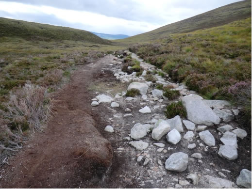
For these very reasons approaches to path building have changed over time: for
example, the 'causeway' that features on the Northern section of the Lairig
Ghru, above Rothiemurchus was a result of path building attempts thirty years
ago and clearly is failing in its role: the trampled area to the side of this
construction indicates that few people choose to walk on this uneven series
of cobbles (see Photo 1 shows an abandonded causeway on the Lairig Ghru). By
undertaking path surveys and becoming more aware of maintenance issues, you
start to understand exactly what it takes to keep paths in good condition, also
the difficulty of gaining funding: while it's relatively easy to gain funding
to build paths, it's much more difficult to find the money to keep maintaining
them.
volunteers
to the features of constructed paths together with the process of recording
details in such a way that maintenance teams can target repair work. Constructed
paths are there to encourage people to stay off fragile ground. This is the
main aim. So while they are not supposed to be a convenient walkway which makes
life easier for the user (a common perception!), the design must still ensure
that walkers choose to use the proffered route and stay within its confines.
For these very reasons approaches to path building have changed over time: for
example, the 'causeway' that features on the Northern section of the Lairig
Ghru, above Rothiemurchus was a result of path building attempts thirty years
ago and clearly is failing in its role: the trampled area to the side of this
construction indicates that few people choose to walk on this uneven series
of cobbles (see Photo 1 shows an abandonded causeway on the Lairig Ghru). By
undertaking path surveys and becoming more aware of maintenance issues, you
start to understand exactly what it takes to keep paths in good condition, also
the difficulty of gaining funding: while it's relatively easy to gain funding
to build paths, it's much more difficult to find the money to keep maintaining
them.
What's Involved
When I adopted my first path I was sent a recording sheet for their chosen route.
Each path is divided into sections, with grid references and some kind of geographical
marker given to identify the upper/lower boundaries. For each section, the number
of drainage features such as cross drains, waterbars and culverts (often quite
difficult to spot), together with length of aggregate surface, side drainage
ditches, revetment and stone pitching are listed - this gives me an idea of
what to expect to find on the path, the aim of the survey being to report on
the condition of these different features. There is no requirement for a volunteer
to undertake any maintenance themselves, but I tend to clear waterbars and crossdrains
of debris if it is a quick and straightforward process.
 Training
courses examine one or two sections of a path in some detail, introducing the
features and path problems that volunteers might encounter. Recording sheets
have been developed for this fieldwork, but these are still in the development
phase: Chris York of Walking-the-Talk (who co-ordinates training and collates
all the data for COAT [Cairngorms Outdoors Access Trust]) is working with volunteers
in an attempt to establish what formula (if there is one) is best suited to
such work. That each volunteer has their own method of recording details became
apparent at a January meeting in Aberdeen when a variety of reports were circulated.
In some cases, each feature given on the reporting sheet (e.g., cross drain,
water bar etc.) has been grid referenced and then all of these are checked when
the person surveys the path. In other cases photos have been taken of 'problem'
points (with locations) and an overall description of the state of the path
has been given, including the problem area. To summarise, the central requirement
is to report the LOCATION (GPS reading) and the NATURE of the problem (photograph).
Personally I tend to identify where there is a problem, giving the location,
recording with a photo but then describing the nature of the problem in my report.
Training
courses examine one or two sections of a path in some detail, introducing the
features and path problems that volunteers might encounter. Recording sheets
have been developed for this fieldwork, but these are still in the development
phase: Chris York of Walking-the-Talk (who co-ordinates training and collates
all the data for COAT [Cairngorms Outdoors Access Trust]) is working with volunteers
in an attempt to establish what formula (if there is one) is best suited to
such work. That each volunteer has their own method of recording details became
apparent at a January meeting in Aberdeen when a variety of reports were circulated.
In some cases, each feature given on the reporting sheet (e.g., cross drain,
water bar etc.) has been grid referenced and then all of these are checked when
the person surveys the path. In other cases photos have been taken of 'problem'
points (with locations) and an overall description of the state of the path
has been given, including the problem area. To summarise, the central requirement
is to report the LOCATION (GPS reading) and the NATURE of the problem (photograph).
Personally I tend to identify where there is a problem, giving the location,
recording with a photo but then describing the nature of the problem in my report.
 Timing
of Surveys and Nature of Path Problems
Timing
of Surveys and Nature of Path Problems
Volunteers are asked to carry out surveys just before maintenance teams go out
to do work. Last year we were asked to survey our paths by the end September
as work was due be done in October. This spring, paths need to be checked by
May. With the higher paths (such as those on Beinn a'Bhuird, or Ben Macdui),
the routes need to be clear of snow before any survey can be carried out. I've
learnt that water is the biggest enemy of any path. Snow melt can cause damage
(particularly in the event of a very rapid thaw, as was experienced last spring).
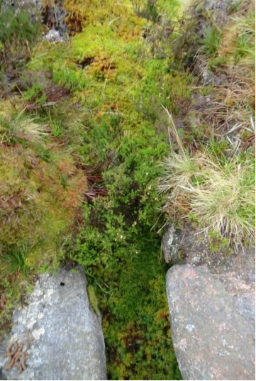
Vegetation growth in drainage ditches and crossdrains can cause water to drain
onto the path (as the path offers the way of least resistance) (Photo 2 shows
an overgrown crossdrain on Beinn a'Bhuird). The surface aggregate can simply
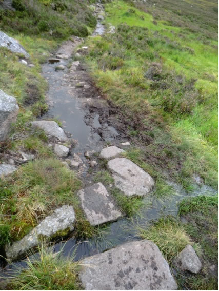
be washed away. Water collecting on paths, due to drainage problems not being
addressed, will cause walkers to widen the path as they try to avoid muddy,
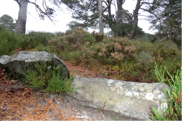
churned up sections (Photo 3). Problems resulting from user wear-and-tear also
have to be addressed. Aggregate can be shifted down a sloping section, due to
the combined effects of gravity and boots or bikes. Lips of crossdrains or waterbars
can become exposed (Photo 4), with the stones eventually becoming loose.
 Equipment
Accessibility of and familiarity with various technological items naturally
impacts on the approach each volunteer adopts to their survey. Provided that
the time/date stamp on a camera is correct, in theory all that a volunteer should
need to do is to switch on their GPS to record the route that they walk and
then survey their path, taking photos as necessary. The route file then needs
to be saved to computer, uploaded and sent to Chris York, together with the
photos and any comments about the path that the volunteer might wish to make.
Some volunteers have a GPS built into their camera and this also seems to work
well (if rather draining on battery power). Smart phones can also be used. I
must confess to adopting a much more laborious approach to my surveys. Having
lost the cable that would allow me to upload any data recorded by my antique
GPS (yes, yes, I know that I could buy another one...), I stop by my point of
'interest', manually record the location (no, I can't be bothered to set a waypoint),
take a photo (which means maintaining a numbering system for photos taken) and
then note (yes, using old fashioned pencil and paper) my comment. This does
mean that I have to match the photos to the field information at home, but that's
fine as this method seems to work best for me.
Further Comments
As a volunteer, I have found that it's worth going on a second - or even third
- training day and fortunately we're always welcome to attend. These serve as
refreshers - and it's also good to share experiences. Other events have been
set up, such as a visit to remote accommodation set up high in the Braeriach
area for maintenance teams. There was an opportunity to witness pathwork in
progress and this really helped me to gain a better understanding of what survey
data is most vital or useful and why.
Of course, as with any occupation, there are hazards. I have nearly been mown
down by a pack of mountain bikes while attempting to clear a cross drain on
the lower reaches of the Lairig Ghru through Rothiemurchus. I'm now seriously
considering investing in a warning triangle (as for car break downs) as a useful
piece of kit to carry with me. Passers-by often express interest in what I'm
doing, but an over-enthusiastic dog who waded into a blocked cross drain that
I was trying to clear, soaking me in the process, was rather taking that interest
to extremes. On one occasion I watched with a sense of incredulity as my carefully
documented survey was grabbed by the wind and deposited in the nearest stream.
I managed to it fish out and it's a testament to the resilience of pencil markings
on paper that when the paper dried out I was able to read perfectly every last
detail of my survey. Last October, I remember trying to finish my survey of
the Beinn a'Bhuird path when it started to snow rather heavily. In desperation
I took to photographing my written survey, just in case all details turned to
mush. The sheets of paper photographed beautifully - but my emergency tactics
proved to be unnecessary as after an hour or so on the radiator at home my notes
were still perfectly clear.
Conclusion
'You'll never view a path in quite the same way ever again': even just walking
my local footpaths I find myself thinking that 'a cross drain just there would
solve the problem of drainage and therefore the trample zone around that small
lake will diminish' or, 'could do with some resurfacing here'. Yes, I'll probably
never be able to walk an 'ordinary' footpath without seeing it differently,
but as I climb higher on Cairngorm paths, I can look across at the views of
these wild, vast, landscapes and fully appreciate what it is that path builders,
outdoors trust and maintenance teams are doing for the preservation of this
frail, upland environment. And hopefully, just hopefully, my surveys are contributing
to that process.
NEMT Front Page
| Previous Page | Volume Index
Page | Next Page | Journal Index Page
Please let the webmaster know if there
are problems with viewing these pages or with the links they contain.